![](/images/other/stat-length.png)
![Tocht Stappen Le Bas Ségala - Vallée de l'Aveyron - Photo](https://media.geolcdn.com/t/1900/400/ext.pjpeg?maxdim=2&url=https%3A%2F%2Fservices.sitytrail.com%2FGeolivesWS%2FDownloadMedia.ashx%3FTrailID%3D102963%26Media%3D4361_4.jpg)
Vallée de l'Aveyron
tracegps
Gebruiker
![Lengte](/images/other/stat-length.png)
Lengte
9,2 km
![Max. hoogte](https://static1.geolcdn.com/siteimages/upload/files/1508320355ic_sort_altitude_max_24dp.png)
Max. hoogte
562 m
![Positief hoogteverschil](https://static1.geolcdn.com/siteimages/upload/files/1508320355ic_sort_den_pos_24dp.png)
Positief hoogteverschil
331 m
![Km-Effort](/images/other/stat-length.png)
Km-Effort
13,6 km
![Min. hoogte](https://static1.geolcdn.com/siteimages/upload/files/1508320355ic_sort_altitude_min_24dp.png)
Min. hoogte
337 m
![Negatief hoogteverschil](https://static1.geolcdn.com/siteimages/upload/files/1508320355ic_sort_den_neg_24dp.png)
Negatief hoogteverschil
333 m
![Boucle](https://static1.geolcdn.com/siteimages/upload/files/16400158638029165_repeat_loop_refresh_sync_direction_icon.png)
Boucle
Ja
Datum van aanmaak :
2014-12-10 00:00:00.0
Laatste wijziging :
2014-12-10 00:00:00.0
![Stappen](https://static1.geolcdn.com/sitytour/trail-icons/101.png)
3h00
Moeilijkheid : Medium
![Scan deze QR-code om de tocht te openen in de SityTrail-applicatie](https://capi.geolives.com/qq0zvz2zws4bq2lad0pu/sitytour/trails/102963/qr.png?size=200)
Gratisgps-wandelapplicatie
Over ons
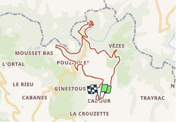
Tocht Stappen van 9,2 km beschikbaar op Occitanië, Aveyron, Le Bas Ségala. Deze tocht wordt voorgesteld door tracegps.
Beschrijving
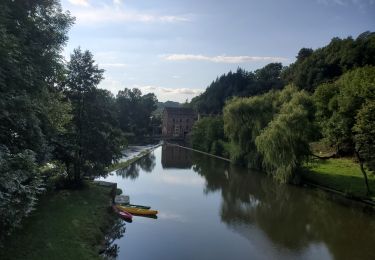
Départ du petit village Cadour (Commune, 3 km de La Bastide L'Evêque). Descendre dans la Vallée de l'Aveyron, à travers bois, jusqu'au Pont du Cayla (photo). Longer l'Aveyron, suivre longtemps ses méandres par un petit sentier, avant de regagner le plateau et Cadour.
Plaatsbepaling
Land:
France
Regio :
Occitanië
Departement/Provincie :
Aveyron
Gemeente :
Le Bas Ségala
Locatie:
La Bastide-l'Évêque
Vertrek:(Dec)
Vertrek:(UTM)
433040 ; 4910919 (31T) N.
Opmerkingen
Wandeltochten in de omgeving
![Tocht Elektrische fiets Brandonnet - Aveyron pont de cayra - Photo](https://media.geolcdn.com/t/375/260/bd1e8117-dc86-4529-9172-15caed75f4a7.jpg&format=jpg&maxdim=2)
![Elektrische fiets Elektrische fiets](https://static1.geolcdn.com/sitytour/trail-icons/205.png)
Aveyron pont de cayra
Elektrische fiets
Medium
Brandonnet,
Occitanië,
Aveyron,
France
![](/images/other/stat-length.png)
34 km | 47 km-effort
2h 30min
![](https://static1.geolcdn.com/siteimages/upload/files/16400158638029165_repeat_loop_refresh_sync_direction_icon.png)
Ja
![Tocht Lopen Brandonnet - brandonnet j1 - Photo](https://media.geolcdn.com/t/375/260/72b76c74-8afe-408b-888f-609a4b9db83e.jpg&format=jpg&maxdim=2)
![Lopen Lopen](https://static1.geolcdn.com/sitytour/trail-icons/103.png)
brandonnet j1
Lopen
Heel gemakkelijk
Brandonnet,
Occitanië,
Aveyron,
France
![](/images/other/stat-length.png)
4,7 km | 6,7 km-effort
59min
![](https://static1.geolcdn.com/siteimages/upload/files/16400158638029165_repeat_loop_refresh_sync_direction_icon.png)
Ja
![Tocht Auto Rieupeyroux - negrefoylt 12 - Photo](https://media.geolcdn.com/t/375/260/ext.jpg?maxdim=2&url=https%3A%2F%2Fstatic1.geolcdn.com%2Fsiteimages%2Fupload%2Ffiles%2F15247431544x4.jpg)
![Auto Auto](https://static1.geolcdn.com/sitytour/trail-icons/401.png)
negrefoylt 12
Auto
Heel gemakkelijk
Rieupeyroux,
Occitanië,
Aveyron,
France
![](/images/other/stat-length.png)
54 km | 70 km-effort
3h 0min
![](https://static1.geolcdn.com/siteimages/upload/files/16400158638029165_repeat_loop_refresh_sync_direction_icon.png)
Neen
![Tocht Stappen Compolibat - compolibat - Photo](https://media.geolcdn.com/t/375/260/ext.jpg?maxdim=2&url=https%3A%2F%2Fstatic1.geolcdn.com%2Fsiteimages%2Fupload%2Ffiles%2F1553511878bg_sport_marche.png)
![Stappen Stappen](https://static1.geolcdn.com/sitytour/trail-icons/101.png)
compolibat
Stappen
Heel gemakkelijk
Compolibat,
Occitanië,
Aveyron,
France
![](/images/other/stat-length.png)
5,3 km | 7,5 km-effort
1h 55min
![](https://static1.geolcdn.com/siteimages/upload/files/16400158638029165_repeat_loop_refresh_sync_direction_icon.png)
Ja
![Tocht Stappen Le Bas Ségala - LA BASTIDE L'EVEQUE ET MARTINET DE LA RAMONDE - Photo](https://media.geolcdn.com/t/375/260/ext.jpg?maxdim=2&url=https%3A%2F%2Fstatic1.geolcdn.com%2Fsiteimages%2Fupload%2Ffiles%2F1553511878bg_sport_marche.png)
![Stappen Stappen](https://static1.geolcdn.com/sitytour/trail-icons/101.png)
LA BASTIDE L'EVEQUE ET MARTINET DE LA RAMONDE
Stappen
Gemakkelijk
Le Bas Ségala,
Occitanië,
Aveyron,
France
![](/images/other/stat-length.png)
5,7 km | 7,5 km-effort
1h 58min
![](https://static1.geolcdn.com/siteimages/upload/files/16400158638029165_repeat_loop_refresh_sync_direction_icon.png)
Ja
![Tocht Stappen Le Bas Ségala - la Bastide L'Evêque martinet - Photo](https://media.geolcdn.com/t/375/260/ext.jpg?maxdim=2&url=https%3A%2F%2Fstatic1.geolcdn.com%2Fsiteimages%2Fupload%2Ffiles%2F1553511878bg_sport_marche.png)
![Stappen Stappen](https://static1.geolcdn.com/sitytour/trail-icons/101.png)
la Bastide L'Evêque martinet
Stappen
Medium
Le Bas Ségala,
Occitanië,
Aveyron,
France
![](/images/other/stat-length.png)
9,2 km | 13,3 km-effort
2h 53min
![](https://static1.geolcdn.com/siteimages/upload/files/16400158638029165_repeat_loop_refresh_sync_direction_icon.png)
Ja
![Tocht Lopen Brandonnet - jogging brandonnet j13 - Photo](https://media.geolcdn.com/t/375/260/ext.jpg?maxdim=2&url=https%3A%2F%2Fstatic1.geolcdn.com%2Fsiteimages%2Fupload%2Ffiles%2F1524743154running.jpg)
![Lopen Lopen](https://static1.geolcdn.com/sitytour/trail-icons/103.png)
jogging brandonnet j13
Lopen
Heel gemakkelijk
Brandonnet,
Occitanië,
Aveyron,
France
![](/images/other/stat-length.png)
8,3 km | 10,6 km-effort
1h 9min
![](https://static1.geolcdn.com/siteimages/upload/files/16400158638029165_repeat_loop_refresh_sync_direction_icon.png)
Ja
![Tocht Stappen Brandonnet - cayla à pieds - Photo](https://media.geolcdn.com/t/375/260/ext.jpg?maxdim=2&url=https%3A%2F%2Fstatic1.geolcdn.com%2Fsiteimages%2Fupload%2Ffiles%2F1553511878bg_sport_marche.png)
![Stappen Stappen](https://static1.geolcdn.com/sitytour/trail-icons/101.png)
cayla à pieds
Stappen
Medium
Brandonnet,
Occitanië,
Aveyron,
France
![](/images/other/stat-length.png)
7,8 km | 10,9 km-effort
1h 20min
![](https://static1.geolcdn.com/siteimages/upload/files/16400158638029165_repeat_loop_refresh_sync_direction_icon.png)
Ja
![Tocht Lopen Brandonnet - footing j7 - Photo](https://media.geolcdn.com/t/375/260/ext.jpg?maxdim=2&url=https%3A%2F%2Fstatic1.geolcdn.com%2Fsiteimages%2Fupload%2Ffiles%2F1524743154running.jpg)
![Lopen Lopen](https://static1.geolcdn.com/sitytour/trail-icons/103.png)
footing j7
Lopen
Gemakkelijk
Brandonnet,
Occitanië,
Aveyron,
France
![](/images/other/stat-length.png)
8,5 km | 10,6 km-effort
1h 0min
![](https://static1.geolcdn.com/siteimages/upload/files/16400158638029165_repeat_loop_refresh_sync_direction_icon.png)
Ja